Views: 0
You open your phone, search for an address, and a small blue arrow guides you with almost magical precision. You turn on your car's navigation system, and it alerts you to real-time traffic to guide you on the fastest route. This small, everyday miracle, which we take for granted, depends on a complex network of satellites orbiting the Earth at over 20,000 kilometers above the Earth: the Global Positioning System, or GPS.
But what if I told you that this technology, so integrated into our lives, is surprisingly fragile?
GPS was born at the height of the Cold War, a project of the United States Department of Defense designed to guide missiles with unprecedented precision and coordinate military operations anywhere on the planet. However, its civilian potential was too great to keep secret. Soon, a version of the signal was released for public use, and the world changed forever.
The ability for any vehicle, ship, or person to know their exact position on a map revolutionized logistics, transportation, agriculture, and even our social interactions. This dependence became so absolute that other world powers were quick to react. Europe developed Galileo, China built BeiDou, and Russia modernized its GLONASS system. The reason was strategic: no nation wanted its critical infrastructure to depend on a system that the United States could, theoretically, "shut down" or degrade for unfriendly countries in the event of a conflict.
Despite the existence of these alternatives, all current global navigation satellite systems (GNSS) share a fundamental vulnerability: their "Achilles' heel."
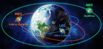
The 24 main satellites in the GPS constellation orbit at an altitude of 20,200 km. By the time their signal passes through the atmosphere and reaches our receiver, it is incredibly weak. Imagine trying to read a book by candlelight several kilometers away. That, in essence, is the delicacy of the GPS signal.
This weakness makes it extremely susceptible to interference. Today, anyone can buy a GPS jammer online—a small, inexpensive device that emits noise on the same frequency, drowning out the weak satellite signal and blinding nearby devices.
Even more worrying is the large-scale use of these techniques. In conflicts like the one in Ukraine, jamming GPS signals is a common electronic warfare tactic to disorient drones, missiles, and troops. Massive interference has also been reported in countries bordering Russia, such as Finland and the Baltic states, affecting civil aviation and shipping. The tech giant is suddenly revealing itself as a colossus with feet of clay.
The Quest for GPS 2.0: Stronger, More Accurate, More Secure
Faced with this fragility, a silent race has begun to develop the next generation of positioning systems. The industry isn't seeking to replace GPS, but rather to augment and strengthen it with new layers of resilience. There are two major avenues for innovation.
1. Low Earth Orbit (LEO) Constellations: A Swarm of Nearby Satellites
The most promising solution is to radically change the system's architecture. Instead of a few very distant satellites, the idea is to deploy hundreds or thousands of satellites in Low Earth Orbit (LEO), at altitudes between 300 and 1,000 km.
Thanks to the advances of the last 50 years and the "NewSpace" revolution, it is now possible to mass-produce and launch small, inexpensive satellites. A LEO constellation would offer a signal up to 1,000 times stronger than that of today's GPS.
This has two transformative advantages:
. Resistance to interference: Such a strong signal is much harder to block. A simple pocket jammer would be useless against it.
. High accuracy: The proximity and power would allow for a positioning accuracy of less than 10 centimeters, compared to several meters for standard GPS.
Companies like the American company Xona Space Systems are already deploying their network, called Pulsar™, with which they plan to have a constellation of 258 satellites in the coming years. Proponents of this technology dream of its application in autonomous driving. With such a robust and precise signal, self-driving cars could navigate with almost absolute certainty, reducing their dependence on the expensive and complex array of cameras, lidars, and radars they use today.
2. Inertial Navigation: The Inner Compass
Another alternative, much older but revitalized by modern technology, is inertial navigation (INS). An INS system doesn't depend on any external signals. It uses a combination of accelerometers and gyroscopes to calculate position by measuring every turn and change in speed from a known starting point. It's like walking across a room with your eyes closed: if you know where you started and record every step and turn, you know where you are.
Historically expensive and bulky, INS systems have become drastically miniaturized and cheaper. Today, they are the backup system par excellence in fighter jets, submarines, and missiles. If GPS fails, INS takes over, ensuring the mission can continue. Even your smartphone uses a basic version of this technology to rotate the screen or count your steps.
The next time you use Google Maps to find a coffee shop, remember the incredibly complex technological choreography that makes it possible. And remember also that, while you search for your destination, engineers and scientists around the world are working to ensure that blue arrow never disappears from your screen.
Technological evolution is an unstoppable force. The fragility of GPS is not an end, but rather the catalyst for a new era of innovation in positioning. An era that promises us a world that is not only better connected, but also safer and more prepared for the challenges of the future.